


Les confins

PMarter
User

Length
25 km

Max alt
1568 m

Uphill gradient
819 m
Km-Effort
36 km

Min alt
1277 m

Downhill gradient
820 m
Boucle
Yes
Creation date :
2025-07-12 08:21:54.91
Updated on :
2025-07-12 13:02:12.185
4h39
Difficulty : Medium

FREE GPS app for hiking
 SityTrail
IGN / Geographical institutes
SityTrail Plus
The world is yours!
About
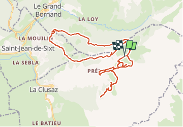
Trail Mountain bike of 25 km to be discovered at Auvergne-Rhône-Alpes, Upper Savoy, La Clusaz. This trail is proposed by PMarter.
Positioning
Country:
France
Region :
Auvergne-Rhône-Alpes
Department/Province :
Upper Savoy
Municipality :
La Clusaz
Location:
Unknown
Start:(Dec)
Start:(UTM)
304474 ; 5088249 (32T) N.
Comments